Kerala project: mobile phones and fisheries
A research project was conducted 2013-2014 among the stakeholders and
roleplayers of the Kerala (India) fisheries industry. The purpose of this
research was to investigate claims that, while at ocean, mobile phones were
being used by fishermen to determine best market prices and then take their
catch there.
These two papers report on the results of this research:
- Steyn, J., Das, M. (2015). Claims of mobile phone use by Kerala fishermen
not support by fieldwork. In Steyn, J., Van Greunen, D. (Eds.). ICTs for
inclusive communities in developing societies: 107-142. Cambridge Scholars
Publishing.
- Steyn, J. (2016). A Critique of the Claims About Mobile Phones and Kerala
Fisherman. The Importance of the Context of Complex Social Systems
The Electronic Journal of Information Systems in Developing Countries,
Vol 74
ISSN: 1681-4835 www.ejisdc.org
This website presents background information, information too bulky to
include in the papers, as well as photo evidence of our research project.
Photos visually illustrate the context of fishing in Kerala, India. They
serve as visual evidence for the context of fishing practices in general, and
the landing centres we visited. Photos are grouped by boat landing centres, as
well as by themes.
Content
Background information
India, Kerala
- The states of India - map
- Kerala State, India - map
- Places - mentioned in primary research, or
important references
- Bathymetric map of Kerala cost
- South Coast - centres where fieldwork was conducted (in alphabetical
order)
- Kovalam (Thiruvananthapuram District
- listed as fishing village and landing centre)
- Neendakara (Kollam District -
listed as fishing village and landing centre)
- Quilon Port (or Kollam) (Kollam
District - listed as fishing village and landing centre)
- Thottappally (Alappuzha
District - listed as fishing village and landing centre)
- Valiathura (or Valiyathura)
(Thiruvananthapuram District - listed as fishing village and landing
centre)
- Varkala (Thiruvananthapuram District
- not listed as fishing village and landing
centre)
- Vizhinjam (Thiruvananthapuram
District - listed as fishing village and landing centre)
- North Coast - centres where fieldwork was conducted (in alphabetical
order)
- Beypore (Kozhikode District - listed
as fishing village and landing centre)
- Chavakkad (Thrissur District -
not listed as fishing village and landing
centre)
- Kochi / Cochin (Ernakulam District -
listed as landing centre)
Vypin (or Vypeen) at Kochi (Ernakulam
District)
- Kalamukku (Ernakulam District
- listed as landing centre)
- Munambam at Vypin (Ernakulam
District - listed as fishing village and landing centre)
- Nyarambalam
- Sri Gosreepuram (Ernakulam
District - not listed as fishing
village and landing centre)
- Thoppumpady at Vypin
(Ernakulam District - not listed as
fishing village and landing centre)
Fish
The states of India
This map shows the states of India. Kerala is on the far southwest coast.
"Kerala" is spelled "Kelala" on this map.

Source: unknown.
Kerala State, India
This map shows the districts of the state of Kerala.
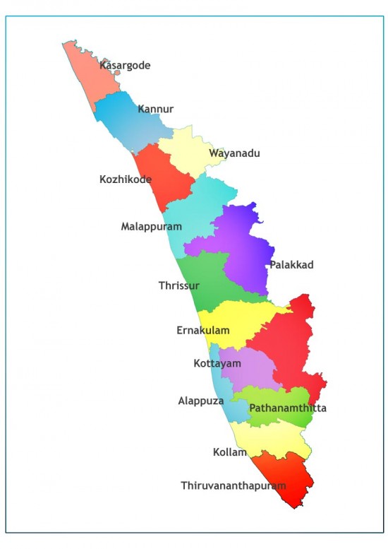
Source: unknown
All photos were taken by either Mohan Das, Jacques Steyn, or Charlotta
Snyman.
Most maps are from Google, and acknowledged. Some maps were sourced from the
internet, but no copyright statements could be found. Search engine return
lists of maps also often do not indicate the source of the image, only the
source of the URL. In many such cases, the source "borrowed" the image from
another unacknowledged source.
© Jacques Steyn 2014